Objectives
- Students will be able to identify different landforms
- Students will investigate weathering, erosion, and deposition
- Students will be able to explain different types of weathering
Direct connection to learning standard(s):
- 4.ESS.1: Earth’s surface has specific characteristics and landforms that can be identified.
- 4.ESS.2: The surface of Earth changes due to weathering.
- 4.ESS.3: The surface of Earth changes due to erosion and deposition.
Intro: A landform is a natural feature of the earth’s surface. Examples include: oceans, rivers, valleys, plateaus, mountains, plains, hills and glaciers.
KWL
What I already know about landforms | What I wonder about landforms | What I learned about landforms |
|---|---|---|
| (Write your thoughts here before doing the activities) | (Write your thoughts here before doing the activities) | (Write your thoughts here after doing the activities) |
- Draw a chart like the one above, and write down your ideas before doing the activities.
Create landforms with clay
- Our partner, Camp Oty’Okwa, can provide clay for teachers in the area to do this activity. Email Emily Kridel to request materials.

Landform dictionary
Step 1: Get at least 3 pieces of paper to make a mini dictionary of the terms from this lesson.
Step 2: Fold your papers in half to create a booklet. Staple them on the sides.
Step 3: Title the booklet “Landform Dictionary” or something similar.
Step 4: Create a page for each vocabulary word and write the definitions. Include a drawing with each landform.
Step 5: More in depth: Create one for just Ohio landforms.
Key
- Mountain: rises above the surrounding land in a limited area , usually in the form of a peak.
- Volcano: an opening in the earth’s crust through which lava, ash, and gases escape.
- Island: a piece of land surrounded by water.
- Hill: a naturally raised area of land, not as high or craggy as a mountain.
- Ocean: the whole body of salt water that covers nearly three fourths of the surface of the earth.
- River: is a natural flowing watercourse, usually freshwater.
- Valley: a lower part in the land, between two higher parts which might be hills or mountains.
- Plateau: a flat, elevated landform that rises sharply above the surrounding area on at least one side.
- Peninsula: an area of land almost completely surrounded by water except for one part connecting it with the mainland.
- Canyon: a deep narrow valley with steep sides and often with a stream flowing through it.
- Plains: a large area of flat land with few trees.
- Lake: a large body of water surrounded by land.
- Desert: a dry, hot, sandy, usually barren and uninhabited area.
Test your knowledge with an online worksheet
- Step 1: Open the Live worksheet link- https://www.liveworksheets.com/worksheets/en/Geography/Landforms/Landform_Map_Drop_ec19231qq
- Step 2: Use your mouse to drag the name to the appropriate landform
- Step 3: Check your answers at the end
Learn: Recognize Ohio Landforms in the Hocking Hills
Sense of place: Now that we can recognize different landforms from all over our planet, let’s dig into some Ohio landforms!
First, let’s take a big jump back in time. Can you imagine most of Ohio covered in ice? Millions of years ago, it was!
A glacier is a huge, slow-moving sheet of ice. As glaciers moved across the land, they left their mark on the landscape. Many of Ohio’s landforms, which are features that you can see on the surface of the Earth, were created by glaciers.
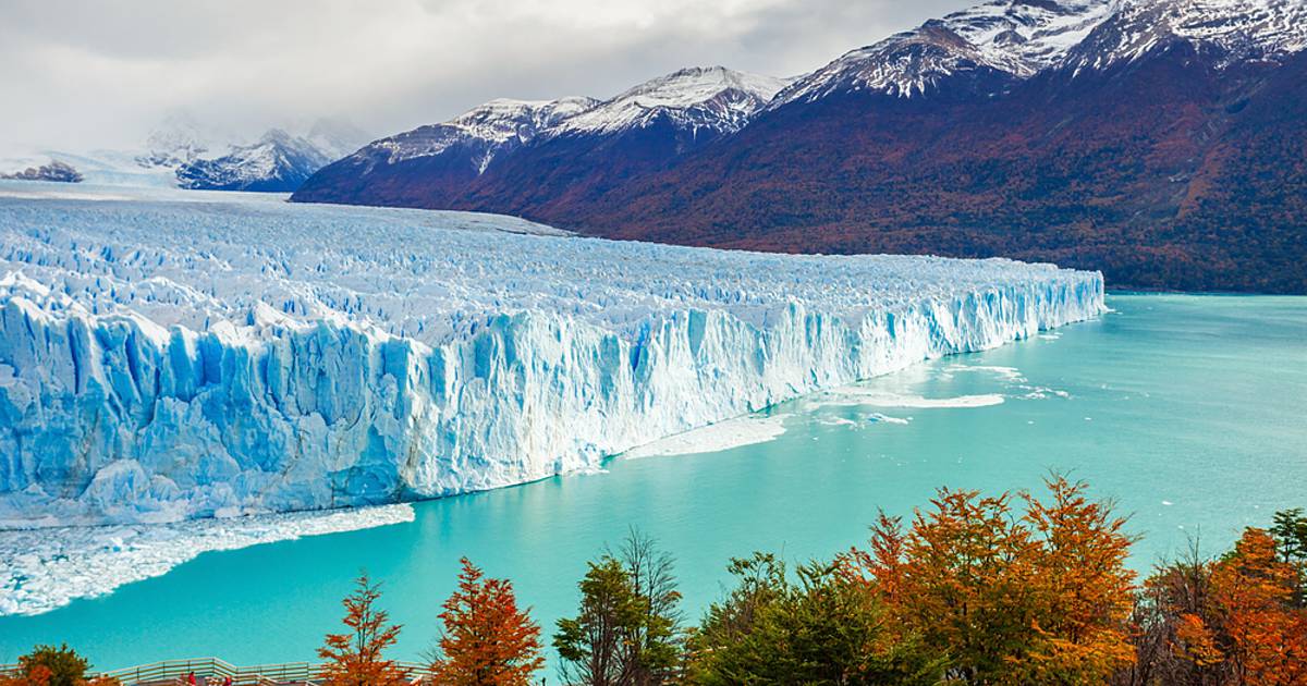
If you live in southeast Ohio, you live in the part of Ohio that is “unglaciated” . That just means the glacier didn’t go through that area. Take a journey with Miranda to see some of southeast Ohio’s geology and how it was created.

The structure in the video is commonly called a rock shelter. A rock shelter is a shallow cave-like opening at the base of a bluff or cliff. This is different from other landforms such as caves because it doesn’t go underground. In the next video, we will see a fun example of how a structure like this is created.
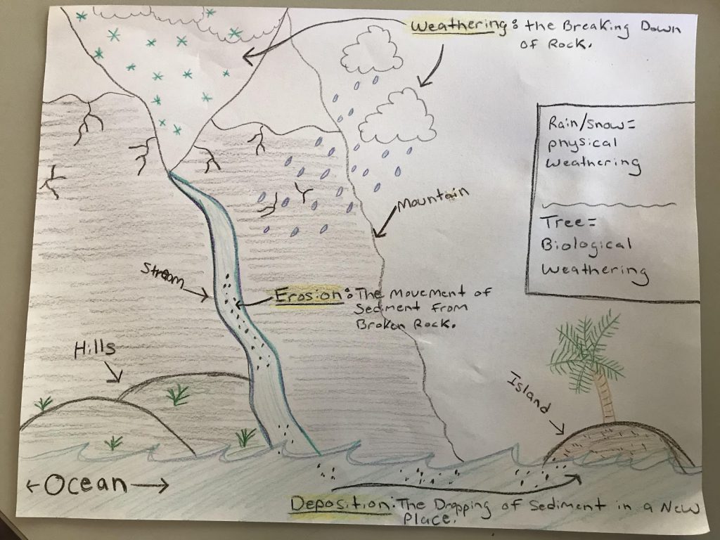
In this next video we will explore what erosion, weathering, and deposition and what their impact on the land is. Here is a chart that explains each:

So now we know what weathering is! Let’s explore the 3 different kinds of weathering.
Here are some examples to think about:
Physical weathering: rust on a tool that was left outside
Biological weathering: weeds coming up through a sidewalk
Chemical weathering: old gravestones disintegrating
In the second video, we did the Oreo cookie example. Miranda talked about how some of the rock was softer than the other. Click on the next video to see a cool experiment with some of the rocks from the rock shelter.
Thank you for watching! Make sure you go out and practice spotting erosion, weathering, and deposition in your area!
Art Activity: Draw what you learned
- Using what you learned in the lesson, draw a picture that includes weathering, erosion, and depositions and as many landforms as you want. Make sure everything is labeled. I attached my example: